The 5 Underground Aquifers Experts Rarely Discuss Publicly
Most people think of water as something you can see. Rivers, lakes, reservoirs. The stuff you watch on the news when a dam breaks or a drought dries out a delta. But the real water story on this planet is happening underground, out of sight, and honestly, far out of most people’s minds.
As the planet gets hotter and reservoirs shrink and glaciers melt, people have increasingly drilled into a largely ungoverned, invisible cache of fresh water: the vast, hidden pools found deep underground. A new study examining the world’s total supply of fresh water warns that Earth’s most essential resource is quickly disappearing, signaling what the paper’s authors describe as “a critical, emerging threat to humanity.” Yet public discourse barely scratches the surface of which specific aquifers are most at risk, or why. Let’s dive in.
1. The Nubian Sandstone Aquifer System: Africa’s Ancient Water Vault
Think of the Nubian Sandstone Aquifer System as a giant, ancient underground cathedral of water buried beneath the eastern Sahara. It is the world’s largest known fossil water aquifer system, located underground in the eastern end of the Sahara desert and spanning the political boundaries of four countries in northeastern Africa, covering a land area of just over two million square kilometers, including northwestern Sudan, northeastern Chad, southeastern Libya, and most of Egypt.
Containing an estimated 150,000 cubic kilometers of groundwater, the significance of the system as a potential water resource for future development is enormous. Libya’s Great Man-Made River project makes use of the system, extracting substantial amounts of water, removing an estimated 2.4 cubic kilometers of fresh water for consumption and agriculture per year.
It is considered a high-stress site due to unsustainable withdrawal rates and demographic pressures, and Libya depends on the aquifer for roughly nineteen out of every twenty liters of its water. Here’s the thing: this water is fossil water, formed thousands to millions of years ago. It does not meaningfully recharge on any human timescale.
Satellite data from the GRACE mission revealed huge water loss in the Nubian Sandstone Aquifer System, amounting to around 50 cubic kilometers over the study period, with depletion attributed to water abstraction alone, driven by increases in irrigated areas and population growth. When this water is gone, it is simply gone.
2. The Ogallala Aquifer: America’s Vanishing Breadbasket Battery
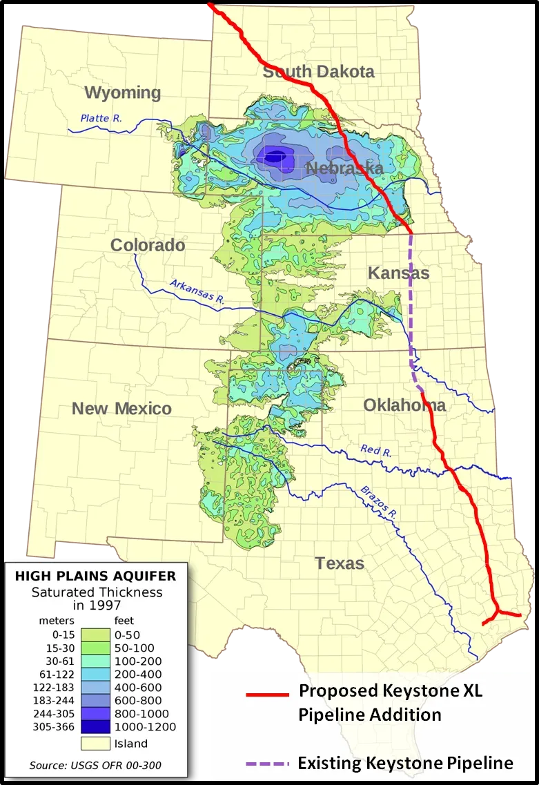
In the Great Plains, the Ogallala Aquifer is a massive underground reservoir stretching from Texas to South Dakota, and it is becoming depleted in many places as farmers draw on the region’s groundwater to irrigate their crops, especially in times of drought. This is the water supply that quietly feeds a significant portion of the American food system, yet it rarely gets front-page treatment.
The Ogallala underlies parts of Colorado, Kansas, Nebraska, New Mexico, Oklahoma, South Dakota, Texas, and Wyoming. From wheat and cows to corn and cotton, the regional economy depends almost exclusively on agriculture irrigated by Ogallala groundwater. Producers are extracting water faster than it is being replenished, which means that parts of the aquifer should be considered a nonrenewable resource.
According to preliminary data presented to the Kansas House Water Committee, aquifer levels in the groundwater management area covering southwest Kansas fell by 1.52 feet between January 2024 and early 2025, a larger drop than the 1.43-foot decline the year before. That kind of consistent, year-over-year loss is alarming when you consider how long it took this water to accumulate.
A University of Texas projection from 2025 has indicated that up to seventy percent of the Texas Panhandle portion of the aquifer could become unusable within twenty years if current pumping rates continue. By 2024, voluntary conservation districts in Texas saw less than fifteen percent of eligible farmers participating in incentive programs. The math here is brutal and the urgency, honestly, is not matching the scale of the problem.
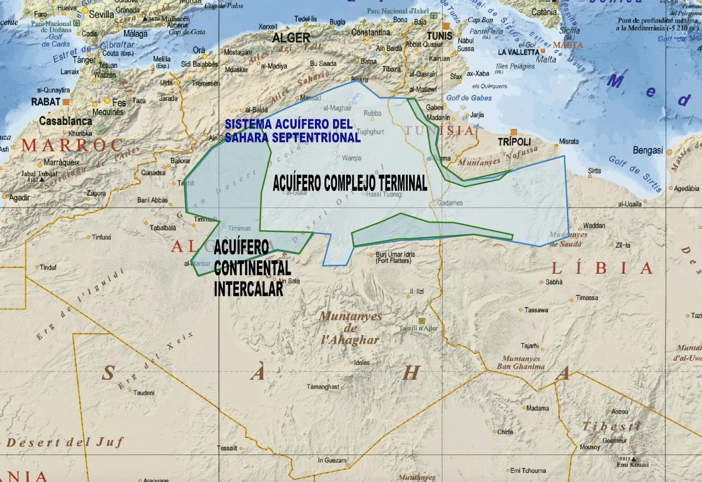
3. The Northwest Saharan Aquifer System: A Shared Crisis Nobody Governs Well
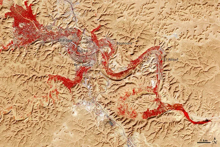
The Northwest Saharan Aquifer System underlies sixty percent of Algeria, almost a third of Libya, and part of Tunisia. It features a cooperation pact between the countries sharing it, but like the Nubian system, it is non-renewable. That word, non-renewable, should stop people cold. This is not a bathtub that refills when it rains.
GRACE satellite data revealed huge water loss in the North Western Sahara Aquifer System of above 30 cubic kilometers over the study period, with depletion attributed to both climate factors and water abstraction. The system sits under some of the most water-stressed, agriculturally active land in northern Africa, and the pressure on it is not decreasing.
Europe has long been proud of its clean water: accessible, abundant, and drinkable. Most of what people drink, irrigate crops with, and use in industries comes from deep underground, from within vast labyrinths of aquifers. This precious groundwater sustains entire populations and has helped turn regions into some of the most sanitary and prosperous in the world. The Northwest Saharan system, spanning countries that include major food exporters to European markets, is a direct upstream link to that prosperity.
Even in developed countries, groundwater monitoring can be spotty to non-existent. Observations from groundwater wells, when they exist, are often managed by multiple resource agencies, measured at differing time intervals, stored in a variety of formats, and often are not readily shared. Without unified data, how is any government supposed to manage a shared, invisible, and depleting resource effectively? It’s hard to say for sure, but the answer seems to be: poorly.
4. The Guarani Aquifer System: South America’s Sleeping Giant Under Pressure
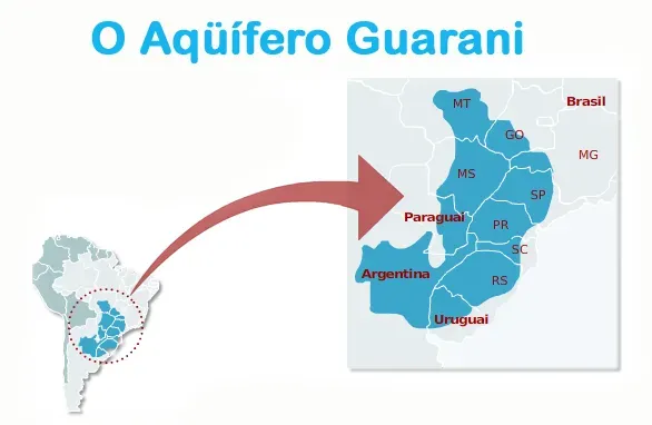
The Guarani Aquifer, located beneath the surface of Argentina, Brazil, Paraguay, and Uruguay, is the second largest known aquifer system in the world and an important source of fresh water. It covers 1.2 million square kilometers, with a volume of about 40,000 cubic kilometers, a thickness ranging between 50 and 800 meters, and a maximum depth of about 1,800 meters. It is, in scale, almost incomprehensibly large. Think of it as a continent-within-a-continent, made of water.
Over 25 million individuals reside within the expansive domain of the Guarani Aquifer System, and over 30 million people in Argentina, Brazil, Paraguay, and Uruguay depend on this water source for their livelihoods. That’s more people than live in Australia depending on one underground system for daily survival.
A 2024 study from São Paulo State University found that the volume of rainwater is insufficient to replenish the Guarani Aquifer and is exceeded by the amount of water withdrawn for use in human activities, endangering the sustainability of the system. São Paulo state alone consumes about 80 percent of the water withdrawn from the Guarani Aquifer in Brazil, primarily through urban wells and crop irrigation, and the downtrend in the reservoir’s water volume requires urgent attention, particularly in the context of the current climate emergency and recurring periods of severe drought.
Total extraction from the Guarani system can exceed 1.04 cubic kilometers per year, and withdrawals in roughly four-fifths of its area are considered non-sustainable, as its waters reached the aquifer more than 30,000 years ago. Essentially, people are drinking ancient water and replacing it with nothing. The clock on that is ticking louder than the public conversation suggests.
5. Europe’s Hidden Aquifer Network: The Crisis Beneath the Prosperity
Most people don’t associate Europe with water scarcity. That’s exactly the problem. The conclusion drawn from an analysis of the most up-to-date EU figures is that water is disappearing and what remains is facing near-irreversible pollution. Over fifteen percent of the aquifers mapped are in poor condition, and that figure represents roughly a quarter of aquifers by surface area.
Persistent and worsening below-normal groundwater levels can be observed in Southern Europe, including southern Portugal, southern and eastern Spain, southern France, and parts of Central and Eastern Europe such as Hungary and northern Poland, as well as regions of South Africa, northwestern India, the western and midwestern United States, parts of Mexico, northern and central Chile, western Brazil, and parts of southern Australia.
Groundwater levels at the Cingla-Cuchillo aquifer in Spain, for example, are falling by an average of 1.6 metres a year, and with around three quarters of Europe relying on aquifers for their drinking water, this is putting supplies under serious threat. That rate of loss, year after year, is not a temporary weather blip. It is structural.
As groundwater is extracted it causes the soil to become more compact, which over time can lead to subsidence. One of the most extreme examples of this process occurred in California’s San Joaquin Valley, where the ground level sunk by nine metres between the 1920s and 1970s, and changes in the structure of the soil mean that this will probably never be reversed. The same process threatens European agricultural heartlands today, and yet it rarely makes the evening news. That silence, more than anything, is what should worry us all.
—
Groundwater is rapidly declining across the globe, often at accelerating rates. UC Santa Barbara researchers presented the largest assessment of groundwater levels around the world, spanning nearly 1,700 aquifers. The work revealed that groundwater is dropping in the vast majority of the aquifers studied. These five systems represent very different parts of the world, different cultures, different economies, but they share one uncomfortable truth: the water beneath them is leaving faster than it is arriving.
Terms such as water stress and water crisis are no longer sufficient descriptions of the world’s new water realities. Many rivers, lakes, aquifers, wetlands, and glaciers have been pushed beyond tipping points and cannot bounce back to past baselines. The language of temporary crisis is no longer accurate in many regions.
What do you think? Are we doing enough to protect what is buried beneath us? Share your thoughts in the comments.