The 6 Underground Aquifers Scientists Are Afraid to Talk About
Beneath our feet, invisible to the naked eye, lies the hidden lifeblood of civilization. Underground aquifers supply drinking water, irrigate croplands, and sustain entire ecosystems across every continent. Yet a growing body of research reveals a deeply uncomfortable truth: many of these systems are collapsing far faster than the public realizes. A new study examining the world’s total supply of fresh water warns that Earth’s most essential resource is quickly disappearing, signaling what its authors describe as “a critical, emerging threat to humanity.” These six aquifers are the ones that keep researchers up at night.
1. The Ogallala Aquifer: America’s Draining Breadbasket
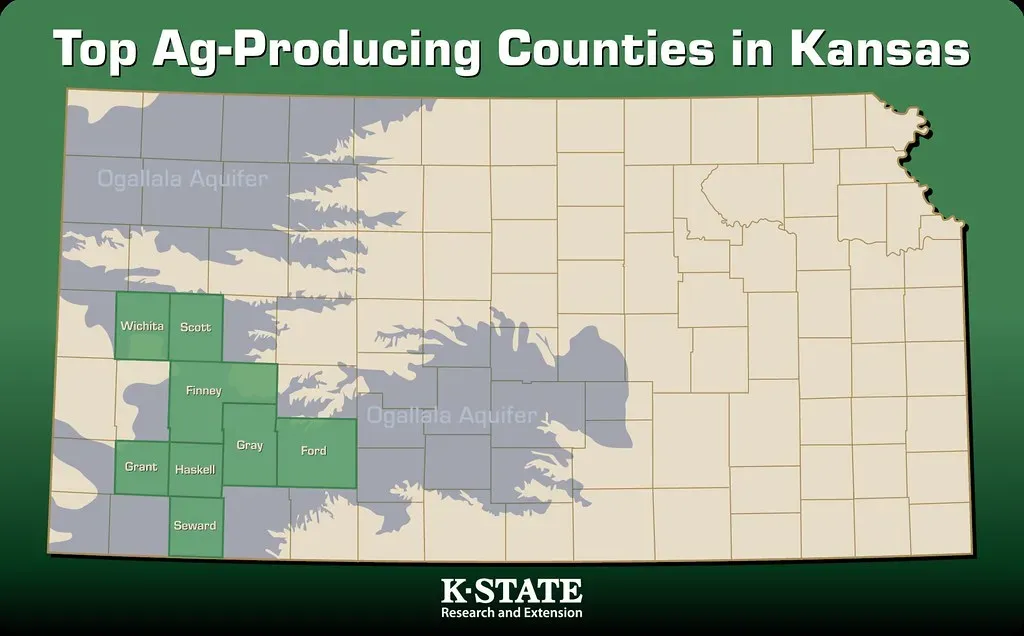
The Ogallala Aquifer spans eight U.S. states and is a major water source for much of the Great Plains. It lies beneath some of the most productive farmland in the country, where large-scale farming of corn, wheat, and soybeans, along with a strong livestock industry, uses water pumped from the aquifer. The problem is deceptively simple: water is leaving far faster than it returns. According to preliminary data presented to the Kansas House Water Committee, aquifer levels in the groundwater management area covering southwest Kansas fell by 1.52 feet between January 2024 and early 2025, a larger drop than the 1.43-foot decline the year before.
In the American Southwest and California, groundwater loss is a familiar story, but over the past two decades that hot spot has also spread dramatically, now extending through Texas and up through the southern High Plains, where the Ogallala aquifer is depended on for agriculture, spreading south through Mexico and into Central America. Projections paint an unsettling picture of what comes next. A University of Texas projection from 2025 has indicated that up to seventy percent of the Texas Panhandle portion of the aquifer could become unusable within twenty years if current pumping rates continue. Voluntary conservation efforts have barely made a dent: by 2024, voluntary conservation districts in Texas saw less than fifteen percent of eligible farmers participating in incentive programs.
2. The Nubian Sandstone Aquifer System: Africa’s Ancient Fossil Vault

The Nubian Sandstone Aquifer System is the world’s largest known fossil water aquifer system, located underground in the eastern end of the Sahara Desert, spanning the political boundaries of four countries in northeastern Africa. Containing an estimated 150,000 cubic kilometers of groundwater, the significance of this system as a potential water resource for future development programs in these countries is enormous. The critical word here is “fossil”: this water accumulated thousands to millions of years ago and does not meaningfully recharge on any human timescale.
Its vast freshwater reserves have the potential to meet growing water demands in the countries sharing it. If not managed carefully, however, the aquifer faces over-abstraction and eventual depletion as its water is ancient and non-renewable. Libya’s dependence on this system is almost total. The Great Man-Made River project pumps water from the Nubian Sandstone Aquifer System in southern Libya to cities on the populous northern Mediterranean coast, with the water covering a distance of up to 1,600 kilometers and providing 70 percent of all fresh water used in Libya. The Nubian aquifer in Egypt alone experiences groundwater depletion rates of approximately 4.44 cubic kilometers per year.
3. The Arabian Aquifer System: The World’s Most Overstressed Underground Reserve

According to NASA’s Gravity Recovery and Climate Experiment satellite data analyzed in a University of California, Irvine-led study, 60 million people depend on the Arabian Aquifer System for water, and it is the most over-stressed aquifer system in the world. The system underlies Saudi Arabia and stretches into Jordan, Iraq, Syria, Kuwait, and Yemen. The Arabian aquifer system, whose groundwater accounts for about 84 percent of total freshwater use across the arid Arabian Peninsula, is among the most overstressed, with almost 90 percent of the water withdrawn going toward agriculture, often paid for by oil revenues.
Starting in the 1980s, Saudi Arabia’s rapid agricultural development fueled by government subsidies resulted in a large increase in water being drawn from the aquifers, many of which are non-renewable. In 1995, an estimated 15.2 cubic kilometers of water was removed per year. By 2004, many natural springs in the area had dried up and the aquifers were turning brackish. The groundwater in the Arabian Peninsula countries is primarily found in transboundary systems such as the Wajid, Umm Er Radhuma, and Wasia Aquifers shared between Saudi Arabia, Iraq, Syria, Yemen, and Oman. These systems have no groundwater-sharing agreements, which leads to a lack of data sharing, unsustainable and uncoordinated development, rapid water depletion, water quality deterioration, and land subsidence.
4. California’s Central Valley Aquifer: The Food Bowl Running on Empty
California’s Central Valley aquifer system ranks among the global hotspots of aquifer depletion. The aquifer is almost liquid gold, supplying California’s agricultural breadbasket that provides roughly a quarter of the nation’s food and three-quarters of irrigated land in the state. The situation is made worse by a brutal feedback loop: when surface water supplies shrink during drought, farmers drill deeper and pump harder. Research has long established that people take more water from underground when climate-driven heat and drought are at their worst. During droughts when California has enforced restrictions on delivery of surface water to its farmers, the enormous agricultural enterprises that dominate the Central Valley have drilled deeper and pumped harder, depleting the aquifer even more.
Half a dozen regions in California rank among the world’s most rapidly declining aquifers, according to research published in the journal Nature in 2024. The physical consequences are already visible from the surface. Over-pumping of the Central Valley aquifer, heavily depleted by irrigating thirsty crops such as almonds during droughts, caused some roads and farmland to subside or sink by several metres. In California, thousands of wells have gone dry after years of drought and overpumping, spreading from the San Joaquin Valley to the Sacramento Valley during the most recent drought.
5. The Guarani Aquifer System: South America’s Hidden Giant Under Pressure
![5. The Guarani Aquifer System: South America's Hidden Giant Under Pressure (File made by Agência Brasil [1] and retouched by the uploader, CC BY 3.0 br)](https://nvmwebsites-budwg5g9avh3epea.z03.azurefd.net/amagicalmess/96c7764853ef8786f92c5daf2c563687.webp)
Over 30 million people in Argentina, Brazil, Paraguay, and Uruguay depend on the Guarani Aquifer System for their livelihoods. That is more people than live in Australia depending on one underground system for daily survival. For decades, the Guarani was regarded as one of the largest and most reliable freshwater reserves in the world. That reputation is now being challenged by hard data. A 2024 study from São Paulo State University found that the volume of rainwater is insufficient to replenish the Guarani Aquifer and is exceeded by the amount of water withdrawn for use in human activities, endangering the sustainability of the system.
São Paulo state alone consumes about 80 percent of the water withdrawn from the Guarani Aquifer in Brazil, primarily through urban wells and crop irrigation, and the downtrend in the reservoir’s water volume requires urgent attention, particularly in the context of the current climate emergency and recurring periods of severe drought. The governance challenge is significant. The aquifer crosses four national borders, meaning that no single government controls how much is extracted. Research published in the journal Science Advances confirms not just that droughts and precipitation are growing more extreme, but reports that drying regions are fast expanding. The dramatic depletion of groundwater and surface water plus the melting of glaciers between 2014 and 2024 has connected once-separate arid places, forming “mega-drying” regions that stretch across whole continents.
6. The Indus Basin Aquifer: A Crisis Beneath the Most Crowded Farmland on Earth
Aquifers beneath Saudi Arabia and Yemen rank first among “overstressed” aquifers globally, followed by the Indus Basin of northwestern India and Pakistan as the second most critically depleted system. The Indus Basin aquifer underpins agriculture feeding hundreds of millions of people across one of the most densely populated regions on the planet. The Ganges-Brahmaputra basin, which includes the broader Indo-Pakistani groundwater zone, suffers aquifer depletion and groundwater pollution stresses only partly offset by its high annual recharge rates. The basin that spans swathes of India, China, Nepal, Bangladesh, and Bhutan is home to roughly ten percent of the planet’s population.
Rapid groundwater-level declines of greater than half a meter per year are widespread in the twenty-first century, especially in dry regions with extensive croplands, and groundwater-level declines have accelerated over the past four decades in 30 percent of the world’s regional aquifers. The Indus Basin sits squarely within this alarming pattern. Bangladesh, where an estimated 97 percent of residents use wells for their drinking water, has degraded large areas of the aquifer system, exposing about 75 million people to arsenic pollution in the aquifer, according to studies. The latest global research reveals that groundwater is dropping in roughly 71 percent of the world’s aquifers, and this depletion is accelerating in many places, with rates of groundwater decline from the 1980s and 1990s having sped up significantly from 2000 to the present.